Scaling Großer Rachel
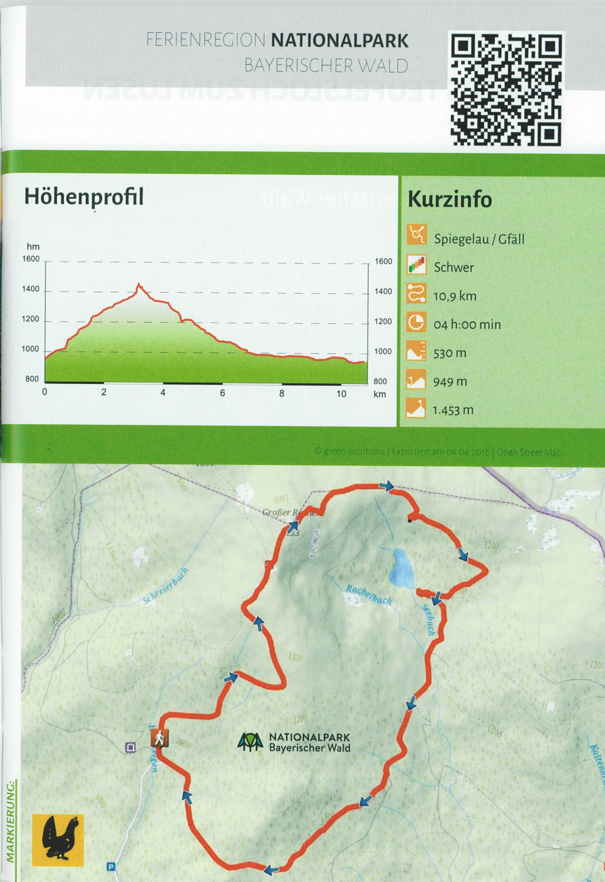
From the “Gfäll” bus stop, follow the Capercaillie trail towards Großer Rachel. Just beyond the bus shelter, the trail rises steeply up the hill and remains at a constant incline, initially through mixed mountain forest and then on through mountain spruce forest higher up.
After around 1.5 hours, you will reach the Waldschmidthaus – where a brief detour to the viewpoint overlooking Rachelsee Lake (viewpoint after around 100 metres) is definitely worthwhile! From here, stone steps lead the final leg up to the summit of Rachel
(1,453 m) – a mountain top dominated by large gneiss boulders. The descent down the other side to Rachel Chapel and Rachelsee Lake is almost alpine in character.
This section particularly impressively demonstrates the diversity offered by untouched mixed mountain forests: Trees felled by storms or snow offer wide-ranging habitats for rare plants and animals. The Capercaillie trail then continues gently back down the hill, before looping back around the mountain – on an almost flat section – to the starting point at “Gfäll”.
Trail marking:
Information:
Starting point:
“Gfäll” car park, from May – October P+R Spiegelau, continue with the Igelbus service from here
Line 7595 (Rachel bus)
Local public transport:
Igelbus bus stop Gfäll (Rachelbus)
Note:
Food and refreshments are available from the Waldschmidthaus (only during the summer season)
After around 1.5 hours, you will reach the Waldschmidthaus – where a brief detour to the viewpoint overlooking Rachelsee Lake (viewpoint after around 100 metres) is definitely worthwhile! From here, stone steps lead the final leg up to the summit of Rachel
(1,453 m) – a mountain top dominated by large gneiss boulders. The descent down the other side to Rachel Chapel and Rachelsee Lake is almost alpine in character.
This section particularly impressively demonstrates the diversity offered by untouched mixed mountain forests: Trees felled by storms or snow offer wide-ranging habitats for rare plants and animals. The Capercaillie trail then continues gently back down the hill, before looping back around the mountain – on an almost flat section – to the starting point at “Gfäll”.
Trail marking:

Information:
Starting point:
“Gfäll” car park, from May – October P+R Spiegelau, continue with the Igelbus service from here
Line 7595 (Rachel bus)
Local public transport:
Igelbus bus stop Gfäll (Rachelbus)
Note:
Food and refreshments are available from the Waldschmidthaus (only during the summer season)

